|


 |
Facts About SVG:

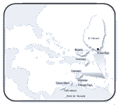
» Click here for a detailed map
Natural hazards:
Hurricanes, Soufriere volcano on the island of Saint Vincent
is a constant threat
Environment current issues:
Pollution of coastal waters and shorelines from discharges
by pleasure yachts and other effluents; in some areas pollution
is severe enough to make swimming prohibitive
Environment international agreements:
Biodiversity, Climate Change, Desertification, Endangered
Species, Hazardous Wastes, Law of the Sea, Ozone Layer Protection,
Ship Pollution, Whaling signed, but not ratified: Climate
Change-Kyoto Protocol
Geography note: the administration of the islands of
the Grenadines group is divided between Saint Vincent and
the Grenadines and Grenada
Photos Of St. Vincent:
For More Information On St Vincent:
1. St Vincent & The Grenadines - Jewels of the Caribbean
http://www.svgtourism.com/
Official site of the Department of Tourism. Includes information on where to stay, activities, events and travel tips.
2. St Vincent & The Grenadines in Pictures
http://www.becouya.com
Photographs from Bequia, Mustique, St. Vincent and the Lower Grenadines.
3. St. Vincent & The Grenadines Information
http://www.scubamom.com/grenadines
Travel information, resort reports, and maps presented.
4. St.Vincent & The Grenadines Merchandise
http://cellarstone.com
Purchase St. Vincent mugs, shirts and more. |
|
Things To Do:
» Facts About SVG
» Places of Interest
» Kingstown
» "The Strip"
» The Grenadines
St. Vincent Quick Facts:
Location:
Caribbean, islands in the Caribbean Sea, north of Trinidad and
Tobago
Area:
total: 340 sq km
land: 340 sq km
water: 0 sq km
Land boundaries: 0 km
Coastline: 84 km
Maritime claims:
contiguous zone: 24 nm
continental shelf: 200 nm
exclusive economic zone: 200 nm
territorial sea: 12 nm
Climate:
tropical; little seasonal temperature variation; rainy season
(May to November)
Terrain:
volcanic, mountainous
Elevation extremes:
lowest point: Caribbean Sea 0 m
highest point: Soufriere 1,234 m
Natural resources: NEGL
Land use:
arable land: 10%
permanent crops: 18%
permanent pastures: 5%
forests and woodland: 36%
other: 31% (1993 est.)
Irrigated land: 10 sq km (1993 est.)
|